San Francisco's Tsunami Risks: The Facts
Due to several sensational news articles in recent days (most prompted by the tragic events in Northern Japan), friends and family (read my mom) have asked me about the dangers of living so close to the coast, and particularly about the risk of a giant tsunami. I currently live a little over 2 miles from the Pacific, and wondered exactly what the possibility was that my apartment would be taken out by a giant wave. I was also tired of all the hearsay about the risks. After sitting down for a couple of hours and doing some serious googling, I decided to write down what I found–hopefully others in San Francisco and even California will find it useful.
FIRST, MY FINDINGS
Yes, San Francisco is at risk. No, I (living in the Sunset) do not face any inundation risk. Continue reading for the details.
WHAT IS A TSUNAMI
Let’s start here because although slightly embarrassing, my knowledge of a tsunami up until recently consisted of the following facts: (1) Tsunamis are giant waves, (2) they can be deadly. Not too impressive.
Typically, a tsunami is generated by an underwater earthquake, where one plate is subducted, and another is pushed upward, causing a large wave. Local tsunamis can also be generated by strike-slip faults (where plates slide left-to-right), where underwater landslides result in large waves, although this is less common (the San Andreas fault is an example of a strike-slip fault) [2]. Waves generated by tsunami’s are obviously much more powerful and are shaped differently than normal, wind-generated waves [1].
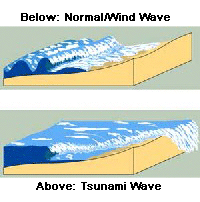
Source: http://www.seismic.ca.gov/tsunami.html
CALIFORNIA TSUNAMI HISTORY AND GEOGRAPHY
California is no stranger to tsunamis, as it faces risks from both local and distant tsunamis. In the state’s recorded history, there have been 82 possible and confirmed tsunamis that have reached California shores. Nearly two-thirds of those events were the result of distant sources [4]. In the San Francisco Bay, 51 tsunamis have been recorded since 1850 [5]. The worst tsunami event in California occurred in 1964 as the result of a magnitude 9.2 Alaskan earthquake. The ‘64 quake produced waves between 10-16 feet along the California, Oregon, and Washington coasts and killed 12 people in Northern California. [1] [4]
California’s greatest risk is from the Cascadia Subduction Zone, the fault between the Juan de Fuca and North American plates. Located off the Northwest coastal US, a Cascadia earthquake would create giant waves that could hit the coast much faster than waves generated from distant events. There would be less time to warn those at beaches and in low-lying areas. The last Cascadia earthquake occurred in 1700 and resulted in waves of 15 feet reaching Japan (which is similar to the height of waves that reached African shores after the Sumatra earthquake) [1].
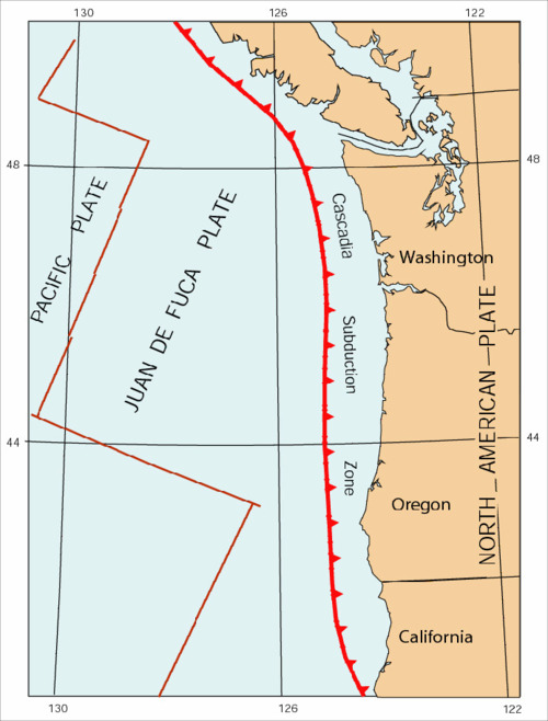 Source: http://www.usgs.gov/science_impact/risk.html
There is a lot of seemingly conflicting information about the potential and probability for tsunamis generated by a Cascadia earthquake. Wikipedia states that the probability of a large Cascadia earthquake occurring in the next 50 years is between 10-14% but I had a hard time pinning down reputable sources. Needless to say it poses a significant risk.
COMPUTER SIMULATIONS
In March 2010, the NOAA Center for Tsunami Research published a special report, modeling forecasted tsunami impacts on the City of San Francisco. In case you were wondering, NOAA stands for the National Oceanic and Atmospheric Administration–a government body that also oversees the National Weather Service and that is basically tasked (among other things) with keeping the general public safe from weather related disasters. The NOAA has actually published many reports for dozens of cities along the western and eastern coasts of the United States (you can find a report for you specific city at http://nctr.pmel.noaa.gov/forecast_reports/ in an easy to navigate Google Map).
The report uses existing tsunami data to create an inundation model for San Francisco–basically, what size waves will reach the shores of the city. The model was calibrated with data from historical tsunami events, and then dozens of scenarios were analyzed. The report found the following:
Sensitivity study results show that the San Francisco Bay area is at greatest risk from a tsunami generated in the eastern portion of the Aleutian-Alaska-Cascadia Subduction Zone. A maximum wave of 7.6 m is predicted for a tsunami generated in Aleutian-Alaska-Cascadia segments 29–38…Tsunami waves from the northern portion of the Kuril and Japan subduction zones and those generated along the southern portion of Chile pose a significant risk to the San Francisco area with waves greater than 1 m predicted. [6]
Different Scenarios Tested along the Aleutian-Alaska-Cascadia Subduction Zone:
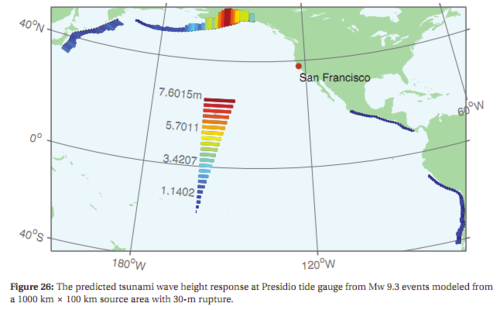
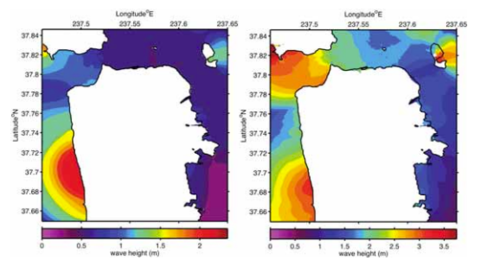
Potential wave heights
This report shows that maximum wave heights actually reaching the shores of San Francisco would be generally no greater than 3-4 meters. It also confirms that that the Cascadia Subduction Zone poses significant risk (unfortunately, a scenario was not tested which simulated a quake occurring directly on the Cascadia fault).
INDUNDATION MAPS
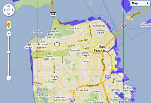
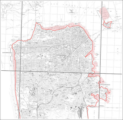 In recent years, California has produced inundation maps that show potential water levels in a tsunami event. Unfortunately they seem rather unscientific–according to the California Geological Survey, “We used one elevation for the whole state. We just drew a line at 30 feet up from sea level.” Fortunately, most wave surges wouldn’t come close to this level. [7]
To view inundation maps for your area, you have two options:
- (Better) Search on an interactive Google Map
- Download an image of the inundation map by California county
If you discover that you live in an inundation zone, you’ll need to make preparations for what you’ll do in the event of a disaster and plan an escape route. Fortunately is looks like the Inner Sunset (where I live), is incredibly safe at roughly 200 feet above sea-level (to see elevation levels for where you live, you can use MyTopo’s interactive maps).
IS SAN FRANCISCO AT RISK?
The short answer is definitely yes. However, only a few portions of the city face inundation, even from a massive wave. Although you should exercise caution when near the shore, and should definitely have an evacuation plan in place if you live in an inundation area, destruction from land-shaking earthquakes is a much larger concern for most San Francisco residents.
HOW TO PREPARE
There are many resources available online for preparing yourself in the event of a tsunami. The USGS has produced an informative video on tsunami preparedness specifically for Northern California (go to 4:58 for some particularly fine acting):
You can also use the following helpful resources:
- AlertSF - Sign-up for SMS alerts based on the San Francisco neighborhood you live/work in
- 72hours.org - Find instructions on what to do in various disasters and what to include in an emergency pack/go-bag (translated into 5 different languages)
- Surviving a Tsunami - Read an interesting USGS report, which uses lessons from past tsunami’s to instruct those at risk on how to survive in the event of a tsunami
I’m sure I haven’t covered all of the resources out there, so let me know if I missed something (or especially if I made a factual error).
SOURCES
[1] http://www.seismic.ca.gov/tsunami.html [2] http://quake.abag.ca.gov/tsunamis/ [3] http://quake.abag.ca.gov/wp-content/documents/ThePlan-C-2010.pdf [4] http://www.seismic.ca.gov/pub/CSSC%2005-03%20Tsunami%20Findings.pdf [5] http://www.baycitizen.org/disasters/interactive/mapping-risk-tsunami-plans-ba… [6] http://nctr.pmel.noaa.gov/forecast_reports/final_reports/03_SanFranciscoCA_33… [7] http://news.discovery.com/earth/california-tsunami-threat.html